Earthexplorer is on a mission to empower organisations to establish sovereign open-core data platforms for monitoring agriculture and water practices. Currently participating in the Dutch business incubator of the European Space Agency (ESA BIC Noordwijk), the startup is making use of satellite data to help governments monitor agriculture, manage water resources and make better-informed decisions. Simplifying complex data for non-experts through its interactive dashboards, the startup standardises field data collection for algorithm development and validates the artificial intelligence (AI) results against real-world farm practices. Read on to discover more from Corné van der Sande, the startup’s founder.
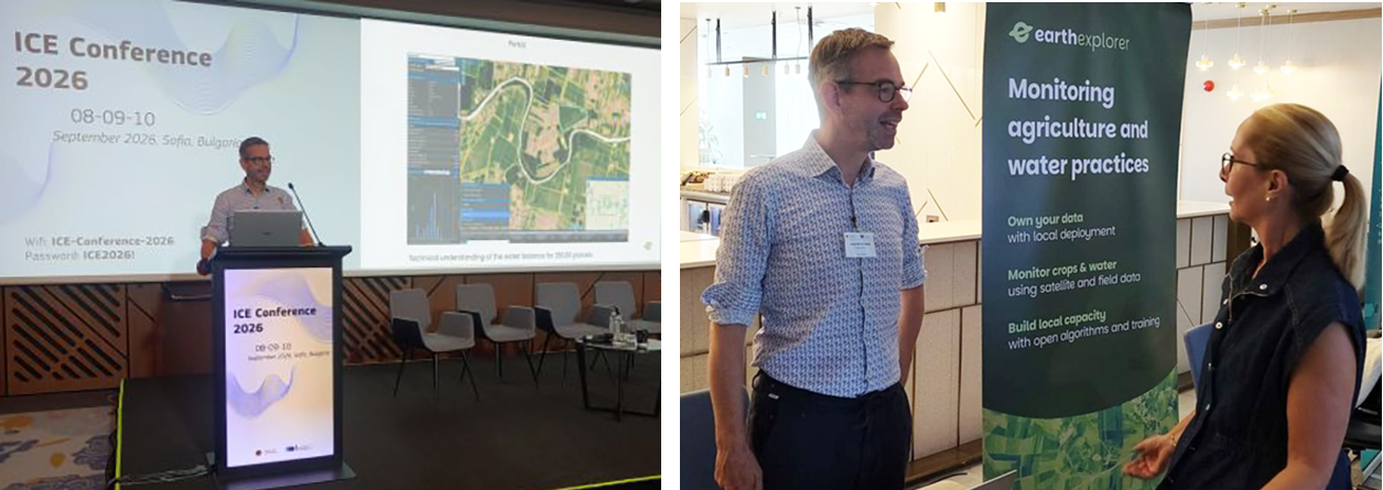
With 25 years of experience in remote sensing, of which almost two decades has been in the agricultural domain, Corné van der Sande is applying his extensive industry knowledge to develop a new generation of monitoring tools. Corné believes that when capacity is built at local organisations they truly can adapt to today’s challenges and he was inspired to establish his startup in the Netherlands earlier this year. Currently incubated at ESA BIC, Earthexplorer combines satellite imagery, ground-based observations and domain expertise to help organisations understand agricultural activities, monitor water use and assess the reliability of AI-generated information. Since joining ESA BIC Noordwijk in July 2026, there have been numerous opportunities for Corné to share his startup’s innovation – such as discussing sovereign solutions at the Open Source Geospatial Foundation conference in Groningen, participating in an ESA-backed student project in Noordwijk and presenting to EU member states at a conference in Bulgaria.
Now, the team is busy working on current projects – ones that have been progressing with Terramira in the Netherlands and ones in conjunction with partner Resing in Morocco – and working toward getting new contacts in member states to further aggregate spatial data into its portal and dashboards. Read on to hear from the founder about the company’s ambitions, its work in Morocco and Europe, and why open technology, collaboration and digital sovereignty are central to its approach.
How do you describe the focus of Earthexplorer?

We want to empower governments and organisations to use information from remote sensing, by giving them easy access to time-series satellite data and algorithm results, which they can validate. There is an enormous amount of satellite data available today, much of it openly accessible. However, just because data is open doesn’t mean everyone can use it. It can be highly technical, and considerable expertise is needed to turn it into information that people can actually work with.
That’s where Earthexplorer comes in. We combine visible time-series satellite data with ground-based information. We empower governments and organisations to use information from remote sensing by facilitating ground-truth gathering for algorithm developers and assessment of the results. These monitoring solutions help organisations understand what’s happening on the ground.
How has your background influenced your career path?
Over the years, I’ve developed a strong understanding of what government agencies need when they’re monitoring agricultural activities. I did two master’s degrees at Wageningen University focused on tropical land use and geo-information science. I always worked on the connection of in situ (ground) data with satellite data to enable scale to tackle problems. When I started out, I was programming in my first job at the company NEO and then, alongside this, I started my PhD at TU Delft. This combination was challenging and although I wrote several peer reviewed articles I never finished it. At NEO, I worked up to becoming a senior advisor and business developer.
What inspired you to establish Earthexplorer?
For the past 5 years, I was working at eLeaf – which has recently merged with NEO and 52impact to become Terramira – and through that work, I gained extensive experience developing algorithms and using satellite data to monitor agricultural practices, biomass and water use. Earthexplorer builds on that knowledge, but we’re taking a different approach. Rather than simply delivering the results of satellite-based monitoring, I want to help organisations understand how those results are produced, whether they can be trusted and how they can develop their own capabilities. The technology is evolving rapidly, but domain knowledge, reliable ground-based information and quality assurance remain essential.
What was your impetus to join ESA BIC Noordwijk?
I saw the value of starting a company in this niche area and so I started looking for guidance and investment opportunities. I knew about ESA BIC and I first decided to join the pre-incubation Ignition Programme.
My professional network has traditionally been centred around Wageningen and the agricultural research community. I’ve maintained strong links with universities throughout my career. ESA BIC gives me a different perspective. It provides access to the space ecosystem, including organisations and companies around Leiden, Delft and the wider space sector.
Can you describe your startup’s space connection and the satellite data you will use?
We utilise data via Copernicus Data Space Ecosystem (CDSE), which is the official platform – supported by the European Commission and ESA – for making Copernicus satellite data accessible, including data from Sentinel-1, Sentinel-2, Sentinel-3, Sentinel-5P and other missions.
For monitoring large areas of agriculture, we make use of evapotranspiration (ET) data as it represents one of the largest components of terrestrial water balance and is key to understanding groundwater dynamics. One important resource for this is WaPOR (Water Productivity through Open access of Remotely sensed-derived data), a database developed for the United Nations’ Food and Agriculture Organisation (FAO), created by Terramira and contracted by the FAO to produce and update the satellite-based data. This provides information about water productivity and agricultural water use. High-resolution data for specific regions may not be open data, so Earthexplorer is collaborating with Terramira for processing that information.
Who do you work with directly and who will benefit from your solution?
The European Union member states need to monitor agricultural activities to ensure that farmers comply with the requirements associated with agricultural subsidies. We are in talks with the organisation responsible for paying subsidies to farmers. This will be even more important when a new compliance regulation comes into force in 2028. I have already been working there for 5 years. Farmers increasingly rely on groundwater for irrigation, but groundwater levels are declining. This creates major challenges for water management.
To manage water resources effectively, you first need to understand how much water is being used and where. Satellite data makes it possible to monitor agricultural water use over large areas, which would be extremely difficult using ground-based measurements alone. You need to combine it with local data and expertise. Earthexplorer has partnered with a local company in Morocco, Resing, which has expertise in hydrology and agronomy and, while they understand remote sensing, they do not have easy access to the software stack we have. And that’s what cooperate. I learn from them about farmers and their irrigation practices, and they learn from Earthexplorer about monitoring at scale. I see this as an equal partnership. Our aim is to combine these different sources of information to provide a clearer understanding of agricultural water use and support better water management decisions.
How are you translating this technology into a practical solution?
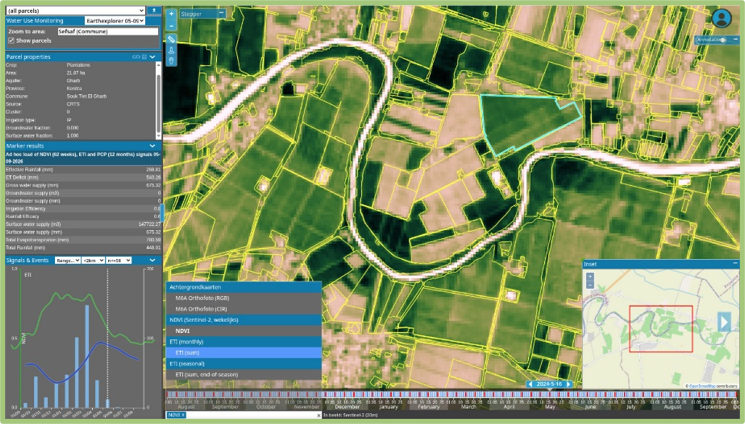
We combine different datasets to create water balances and understand what’s happening at the level of individual agricultural parcels. For example, we need information about rainfall, irrigation and water consumption to build a meaningful picture of agricultural water use. It is like we can see a movie of a whole season from each parcel. We’re also working with very high-resolution satellite imagery, including imagery with a spatial resolution of around 50 cm. The challenge is to integrate all these different sources of information and turn them into something useful.
The portal we are developing brings together satellite observations, ground-based information and agricultural monitoring results. It allows users to explore the information spatially and understand what’s happening in different locations, while at the same time being accessible to people from different disciplines. We work with agronomists, hydrologists and geohydrologists, and they don’t necessarily have detailed knowledge of remote sensing. It also helps users understand what satellite data can tell them and, equally importantly, what it cannot tell them. That’s essential because remote sensing has limitations. We want users to understand the information they’re working with rather than simply accepting a result generated by an algorithm. The Moroccan portal is an important starting point for our wider technology development.
What has been your initial focus during incubation?
We have three main areas of focus. The first is agricultural water monitoring, particularly our ongoing work in Morocco. The second is helping European government agencies in getting trusted algorithms for agricultural monitoring. The third is supporting governments – and indirectly farmers – in quality assurance and the compliance of European regulations.
These three areas are closely connected. They all involve combining satellite observations with real-world agricultural knowledge to create reliable, practical information. We’re developing technology that can support these different applications, rather than creating entirely separate solutions for each project. The central idea is to make complex spatial data understandable and useful to the people who need it.
We are currently focusing on new EU member states and also on current member states that may need to establish or further develop their agricultural monitoring systems. The EU paying agencies need to assure the quality of monitoring they need to deliver. This is challenging as agriculture is under pressure and regulations can change. We believe a paying agency is best served by a team that is both able and eager to deliver a platform that can give them control. That is the spirit in which we would like to work.
Did you make new contacts at the recent conference in Bulgaria?
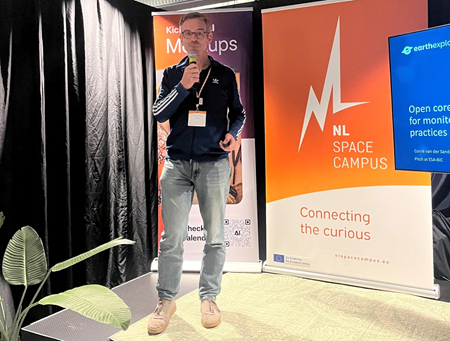
The conference was extremely valuable because it allowed me to present our work in Morocco and discuss our approach with representatives from European government agencies. I’ve been involved in this professional community for many years, so it was also an opportunity to reconnect with people and introduce Earthexplorer as a new venture.
One of the most encouraging things was the response to our ideas about open technology and digital sovereignty. During the conference, I asked participants whether an open software stack and digital sovereignty were important to their organisations. Ninety-eight per cent of respondents said yes. That was very encouraging because these principles are central to our business proposition.
Government agencies increasingly recognise that they need greater control over their technology and data. They don’t necessarily want to depend entirely on external companies delivering results through closed systems. They want to understand the algorithms, assess their quality and, in some cases, experiment with them on their own. The conference helped validate our approach. It confirmed that there is demand for tools that give government organisations more transparency, flexibility and control.
Get financial support (€60K funding) to help launch your space business >>
What are the main challenges you expect to face as Earthexplorer grows?
One of the biggest challenges is working with government organisations and encouraging them to adopt new technology. I believe capacity building is extremely important. Rather than simply delivering a service, we want to help organisations understand the technology and become more capable of using it themselves. That’s a different approach from the traditional model of providing a closed software product. It also creates challenges for our own business model. We need to find the right balance between making technology openly available and building a sustainable company.
Another challenge is the changing environment in which our customers operate. Climate change is creating more frequent droughts and periods of intense rainfall, placing increasing pressure on agriculture. Governments will need better information to respond to these challenges. Remote sensing can make a real difference, but organisations need to invest in the infrastructure and expertise required to use it effectively.
How do you see AI influencing or impacting your workflow?
AI is already revolutionising how we develop technology. It’s becoming much easier and faster to create algorithms, process large datasets and develop applications. I see enormous opportunities in that. However, I also believe AI will make competition more disruptive and intense. Developing a prototype or creating an algorithm is becoming easier, so companies need to think carefully about where they provide real value.
For Earthexplorer, that value lies in domain expertise, access to reliable ground-truth information and quality assurance. AI can generate results, but we still need to understand whether those results are correct. We need to know how an algorithm performs under different conditions and whether its conclusions can be trusted. That’s particularly important when the information is being used by government agencies to make decisions.
So, I do see possibilities of AI, that algorithms can be made much faster and can combine a lot of data, as being very positive. But I want Earthexplorer to be a key component in the process – come to me for proper ground truth, the connection with remote sensing and your results that get a reliable quality assurance.
What are you aiming to achieve by the end of your ESA BIC incubation?
Our goal is to develop a portal and a series of dashboards that aggregate spatial data and transform it into information that non-remote sensing experts can easily understand. We already have an initial technical portal, and we want to develop it further during the 2-year incubation programme. The aim is to make the technology more modular, accessible and adaptable to different applications.
We also want to integrate different types of information, including satellite observations, ground-truth data and algorithm outputs. From a commercial perspective, we’re looking at a subscription-based model. At the same time, we want parts of the technology to be open source. This would allow organisations to use and build on the technology, while creating opportunities for collaboration and community development. I think this approach reflects what our customers increasingly want. They don’t necessarily want to depend on a single supplier for everything. They want flexibility, transparency and the ability to develop their own capabilities. Our ambition is to provide the expertise, technology and support that make that possible.
What aspects of the programme appeals to you?
It’s not only about funding. It’s also about connecting with companies that can support technical development, exploring new partnerships and understanding opportunities within the European space infrastructure. For instance, making connections in the CDSE. This is completely open and everybody in the Earth observation segment can use it to turn Sentinel data into actionable applications. We’ve already started using its APIs in our technology and I see considerable potential to build on that. Being part of ESA BIC gives us opportunities to explore these connections while developing both our technical and commercial roadmaps. I’m also looking forward to the serendipity of it all, of the new group of people I meet and the potential prospects that can bring.
“We empower governments to use remote sensing information by facilitating ground-truth gathering for algorithm developers and assessment of the results”
Corné van der Sande, CEO EARTHEXPLORER
How useful was the SBIC pre-incubation programme to prepare you for applying to ESA BIC
It was very helpful. With so many years working as a business developer, one could think that formulating a startup is easy; it’s not. The Ignition Programme forced me to go out of my daily bubble and dive into the client’s user pains.
Any advice for any budding entrepreneurs?
Try the Ignition Programme to bring focus to your business plan. Ideas easily come at the table when you are with friends. But do these ideas still hold when you have to make a customer journey, a value proposition, business model and your obtainable market? It is a great idea to follow the pre-incubation trajectory if you want an honest answer.
What organisations have been key for your journey so far?
NEO and eLeaf – now Terramira – have been helpful in my journey to grow as a professional, but also now at the start of my company. With Terramira, I have a business agreement and a data partnership, which allows me to continue with certain projects and, most importantly, with my partner and clients in Morocco. I have worked very pleasantly the past years with Resing and we understand the both the power of combining local and satellite data.
And finally: What’s your favourite thing about space?
When you look from above to Earth, you easily understand the landscape – it is magic. However, it is a still image, and it makes you wonder how everything is related in time. You need to know the situation on the ground and then scale it with remote sensing, which needs cooperation with many disciplines. I think that is where Earthexplorer comes in. We need to be humble and work together for the benefit of the planet. Local data can be scaled with remote sensing to information that covers a large area and this is needed to understand the challenges in agriculture and climate change.

ABOUT: Earthexplorer empowers governments with a sovereign, open-core platform to monitor agriculture and water use from space. The company delivers portals to monitor agricultural parcels nationwide with a sharp focus on ground truth gathering and algorithm validation. Technical portals and easy-to-use dashboards deploy locally, keeping sensitive data in the clients’ hands. From governments in the Middle East, North Africa, West Africa and Europe, Earthexplorer helps decision-makers tackle the water crisis and build climate-resilient agriculture. The company joined ESA’s business incubator programme at ESA BIC Noordwijk in July 2026. earthexplorer.nl
The ESA business incubation programme promotes space business ideas:
Discover the innovations of the current incubatees being supported by ESA and NLSA.